



- Oct 5, 2026
- Featured Insights
From Earthquakes to Scientific Inquiry - When Earth Science Meets AI Technology
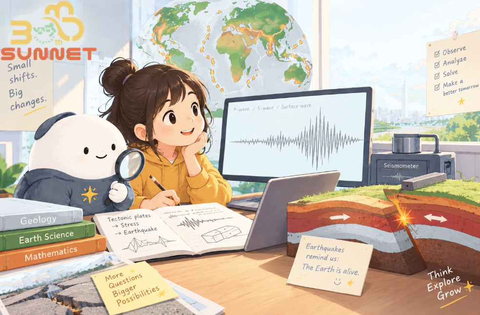
Taiwan is located at the boundary between the Philippine Sea Plate and the Eurasian Plate. For millions of years, these two tectonic plates have been continuously pushing against each other. This powerful geological process not only helped raise Taiwan above sea level, but also created numerous fault zones beneath and around the island.
The movement is still continuing today. As a result, Taiwan experiences earthquakes frequently, ranking among the most seismically active regions in the world. Investigating and monitoring faults is therefore an important long-term scientific effort.
To help everyone understand this dynamic land we live on, we’ve organized four key scientific concepts that are especially suitable for reading and discussing with children.
1. What Is a Fault? How Does It Work?
Definition:
A fault is a fracture or zone within the Earth’s crust along which the rocks on either side have moved relative to each other.
How energy is released:
Stress and energy continuously build up underground. When the stress exceeds the strength of the surrounding rocks, the rocks can suddenly slip along the fault. The energy released during this movement is what we experience as an earthquake.
An important concept:
A fault is not something that simply breaks once and then becomes inactive. The same fault can accumulate stress repeatedly and move again after hundreds or even thousands of years. This is why continuous, long-term scientific monitoring is so important.
2. Onshore Faults: An “Open Book” of Geological Data
Research methods:
Faults on land are relatively accessible to scientists. Researchers can conduct geological drilling, excavate trenches to examine layers of the Earth, and install high-density monitoring instruments on the surface. As a result, much more data can be collected over time.
A representative example:
One of the best-known examples is the Chelungpu Fault, which ruptured during the 1999 the 921 Earthquake. The earthquake left clear evidence of surface displacement, helping drive Taiwan’s subsequent efforts to systematically monitor and update information on dozens of active faults.
3. Offshore Faults: A Knowledge Gap Waiting to Be Filled
The challenge of observation:
Taiwan’s surrounding waters are also filled with fault zones, but investigating the seafloor is extremely challenging. Scientists need to deploy large marine research vessels, use sound waves to map the seafloor, and place seismic instruments on or beneath the ocean floor.
What we still need to understand:
Because offshore investigations are expensive and time-consuming, the density of available data is much lower than for faults on land.
Understanding how these offshore faults rupture and how large an earthquake they may generate is therefore a key part of assessing earthquake risks around eastern and northern Taiwan.
4. What the April 3 Earthquake Taught Us: Combining Scientific Observation with AI
The April 3, 2024 Hualien Earthquake once again brought an important question to the forefront:
How much do we really know about the faults beneath Taiwan’s surrounding waters?
After an earthquake occurs, scientists need to collect and compare data as quickly as possible in order to estimate the extent of the rupture and assess potential risks. The detailed structure of the fault, however, often takes much longer to understand and confirm through continued research.
Aftershocks can provide valuable clues about what is happening underground, but these records are time-sensitive. If scientists do not conduct rapid post-earthquake observations, important scientific data may be lost.
Faced with enormous amounts of data and significant gaps in our knowledge, scientists are increasingly turning to two important approaches:
🔬 Long-Term Scientific Observation
Through networks of seismic stations, ocean-bottom seismometers, and other monitoring systems, scientists can continuously collect data and gradually fill in the gaps in our understanding of offshore faults.
🤖 AI-Assisted Earthquake Monitoring
Earthquake monitoring generates enormous amounts of data. Even small earthquakes can provide important clues about subtle movements and activity along underground fault systems.
With the assistance of AI, scientists can analyze these massive datasets more quickly and accurately, helping them identify and understand the real-time activity of Taiwan’s fault systems.
【Parent-Child Mini Mission】
Tonight, try asking your child this question:
“We can’t see what is happening on the seafloor with our own eyes. So how can scientists find out whether there are faults under the ocean?”
Hint: Sound waves, seismic waves, marine research vessels, and AI-powered data analysis.
Use this simple question to spark your child’s curiosity about Earth science, scientific investigation, and the latest applications of technology!
Image source: Seismological Center, Central Weather Administration (CWA)【Think & Explore|A Math Mini Mission】
Earthquake × Math|Can You Read the Earthquake?
Mini Mission
Imagine these small earthquakes were recorded in one day:
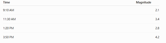
Try these questions:
1. Which earthquake had the greatest magnitude?
2. What is the difference between the largest and smallest magnitude?
3. How many earthquakes were recorded?
4. How much time passed between the first and last earthquake?
5. What patterns do you notice in the data?
From questions to discoveries, SunStart inspires children to explore, think, and grow.
#ScienceEducation
#EarthScience
#DisasterPrevention
#Geology
#Faults
#AIandTechnology
#ParentChildLearning
#FamilyLearning
#sunstart